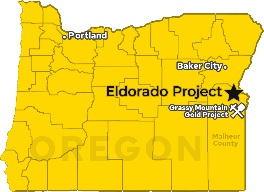
The Eldorado Project is a district-scale land position totaling 7,915 acres (32.03 km2) located 60 kilometres (38 miles) northwest of Vale in Malheur County, Oregon. The project benefits from excellent nearby infrastructure, road accessibility, and local and federal support, as evidenced by the nearby Grassy Mountain project, located just 36 kms SSW of Vale. The Grassy Mountain project recently signed a Record of Decision (ROD), by the Bureau of Land Management (BLM), which is the federal approval that completes the NEPA environmental review. This allows the project to advance from permitting into a construction ready stage on federal lands and paves the way for additional development of mining projects on federal lands in eastern Oregon.
The project consists of the Eldorado West and Eldorado East properties, both featuring highly prospective geology.
Eldorado West hosts a historical resource estimate* of 1.98 million oz at 0.75 g/t gold, with much of the property still unexplored. The project has demonstrated strong metallurgical recovery, making it amenable to heap leach extraction and gravity/flotation. 2025 drilling extended gold mineralization to over 800 meters and confirmed broad, coherent zones of mineralization.
EC-01: 288m @ 2.01 g/t gold
Including 175m @ 3.07 g/t gold, extending to 250m depth
ED-26: 92.96 m @ 1.55 g/t gold
Incl. 25.91 m @ 2.39 g/t gold • Extending mineralization northward
ED-28: 254.51 m @ 1.56 g/t gold
Incl. 42.67 m @ 2.84 g/t gold • Expanding feeder zone at Herman southward
New Discovery at Striker Area
ED-32: 4.57 m @ 0.87 g/t Au • ED-36: 3.05 m @ 1.23 g/t Au
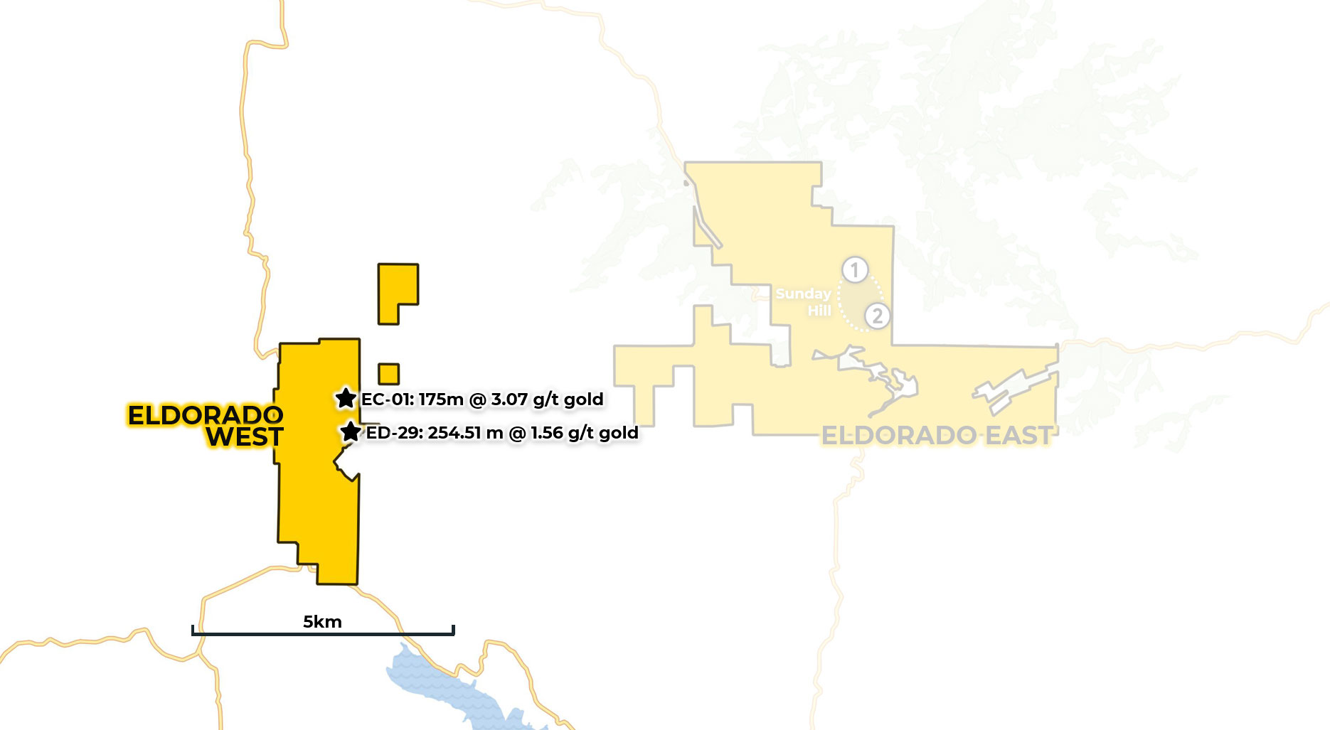
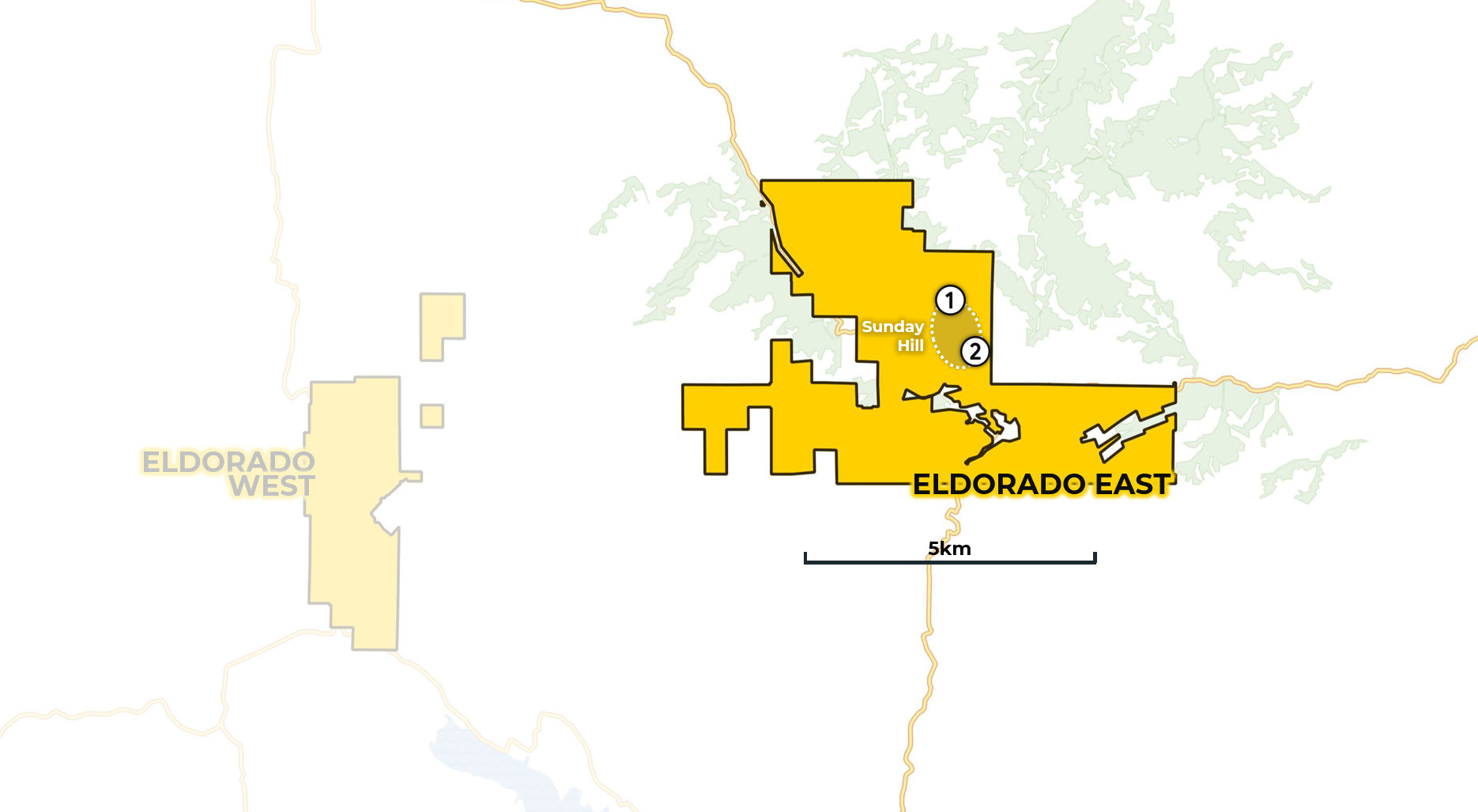
The recently acquired 5,867-acre Eldorado East property features historical open-ended resource estimates at Sunday Hill** of 154,000 oz+ at 23.15 g/t gold, plus an additional 50,000 oz+ at 9 g/t gold. Ground-work, sampling and drill permitting are currently underway, with the property expected to be ready to drill by Spring 2026.
Historical open-ended resource estimates at Sunday Hill**:
1 154,000 oz+ at 23.15 g/t gold
2 50,000 oz+ at 9 g/t gold
Recently Acquired
5,867 acres added to district-scale land position
Drill Ready by Spring 2026
Permitting and ground-work underway
*All historical resource estimates are based on prior data and reports prepared by previous property owners. A qualified person has not done sufficient work to classify historical estimates as current resources in accordance with CIM (Canadian Institute of Mining, Metallurgy and Petroleum) categories and the company is not treating the historical estimates as current resources. Significant data compilation, redrilling, resampling and data verification are required by a qualified person before historical estimates can be classified as a current resource. There can be no assurance that any historical mineral resources, in whole or in part, will ever become economically viable. In addition, mineral resources are not mineral reserves and do not have demonstrated economic viability. Even if classified as a current resource, there is no certainty as to whether further exploration will result in any inferred mineral resources being upgraded to an indicated or measured resource category.
**The referenced resource estimates for mine sites on the Sunday Hill Property are considered historical in nature, are based on prior data prepared by a previous property owner, and do not conform to current CIM categories. While the Company considers the estimates to be reliable, a qualified person has not done sufficient work to classify the historical estimates as current resources in accordance with current CIM categories and the Company is not treating the historical estimates as a current resource. Significant data compilation, re-drilling, re-sampling and data verification may be required by a qualified person before the historical estimates can be classified as current resources. There can be no assurance that any of the historical mineral resources, in whole or in part, will ever become economically viable. In addition, mineral resources are not mineral reserves and do not have demonstrated economic viability. The Company is not aware of any more recent estimate prepared for the Sunday Hill Property.
The 2025 diamond core drilling program concluded with hole EC-09 on December 22, 2025. Core holes EC-04 to EC-09, totaling 2024 meters, are currently being logged and processed.
The Company recently completed airborne radiometric and magnetic geophysical surveys over both Eldorado East and Eldorado West properties to better understand the regional and deposit-scale mineralizing structures.
Full results are still being processed, however preliminary results of this survey support the geological model that the mineral system could extend far beyond any known exploration to date.
941-line kilometers flown at 50-meter line spacing to aid in delineating exploration targets for testing in 2026.
Detailed geologic mapping on Eldorado West and reconnaissance mapping at Eldorado East completed with multi-element geochemistry.